

Services

Mining and Construction Drone Services
By using the most advanced Software in the industry, together with our powerful drones, we can help to digitise your site with 3D models. These models provide valuable information about the site can be used to track the site progress, verify GPS coordinates, calculate bulk volumes, and generate precise surveys.
We use Precision Hawk, Drone Deploy, SiteScan and other applicable software packages.

Telecom and Power Lines Drone Services
Our powerful drones are capable of precision lifting of heavy loads (Up to 100kg), such as cellular antennas and power line guide ropes. The drones can replace the use of helicopters, traditionally used on such installation sites, shortening the installation time and costs.
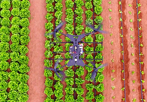
Drone Agriculture Services
Using drones can help farmers carefully monitor their crops. With our attached spraying system, the drone can accurately spray the plants, eliminating the need for traditional aircraft cropdusting. Using advanced software and optic systems, plant health and field heat maps data can be generated and analysed to improve the farm's yield. The software can also be used for counting of crops, cattle or wildlife.
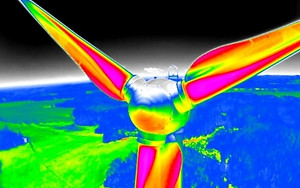
Drone Infrastructure Inspection
LIDAR and FLIR sensors give us the ability to collect vital performance information, such as thermal hot spots or structural weak points. We can use these technologies to inspect oil and gas pipes, power lines, solar farms and wind mills. Such inspections can be preplanned and automated.
The valuable inspection data can predict potential dangers early on, and can help save lives and infrastructure.